
Areas around Calgary are being called an “island of dryness” in the midst of the Alberta prairies, with moisture conditions below normal for this time of year.
“I think the story for moisture starts back in August of 2022,” Ralph Wright, manager of meteorological applications and modelling with Alberta Agriculture and Irrigation, explained in a recent interview. “In June there was well above normal rainfall, and some areas were actually a little bit too wet. But come August, the tides turned again, and what we saw was a general drying pattern and well above normal temperatures until October. And this helped deplete the soil moisture.”
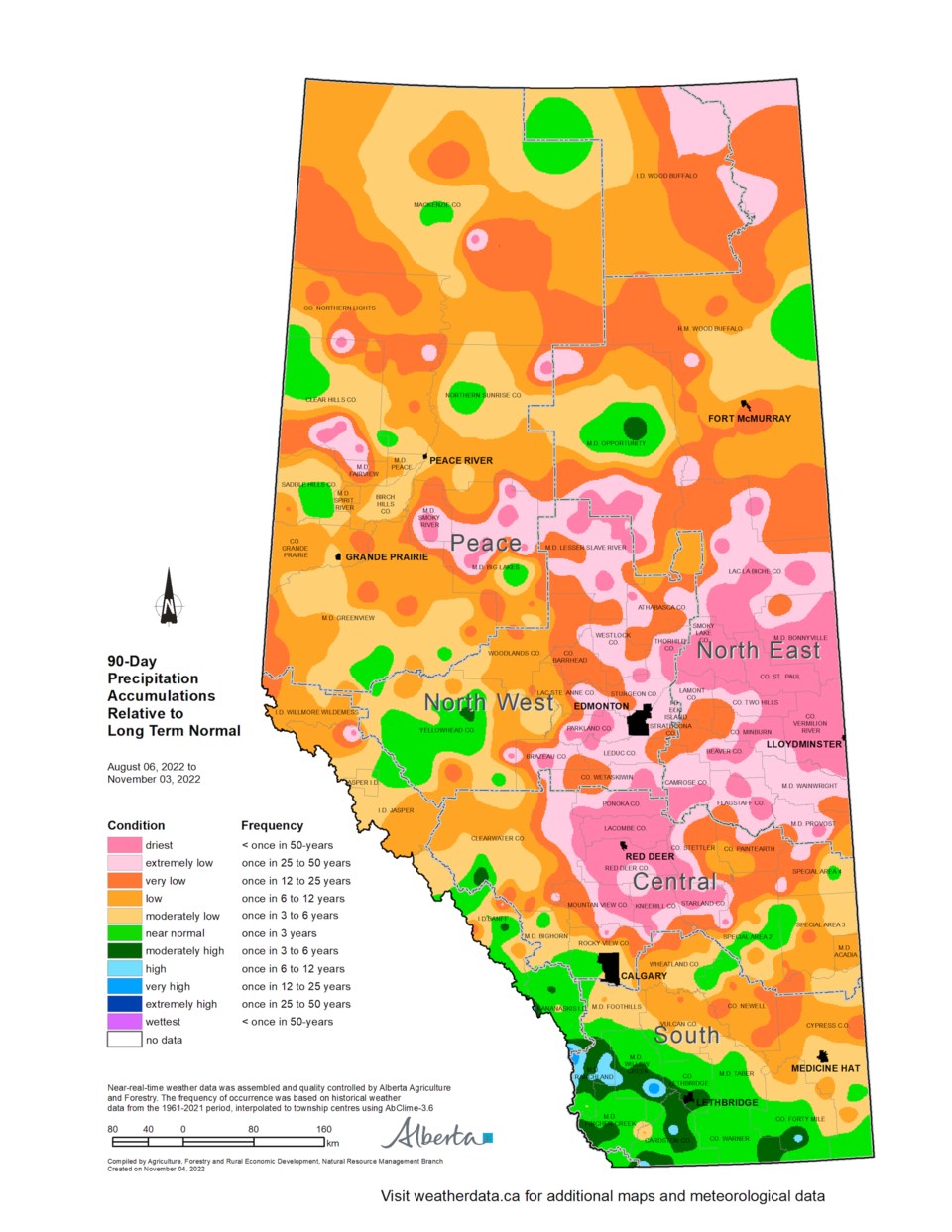
So far this winter, the Calgary area has had below-normal precipitation in the last 90 days heading into what is, traditionally, the two driest months of the year in January and February.
According to Wright, during this timeframe, Calgary has experienced a once every three-to-six-years low in precipitation. Slightly further north in Airdrie, the region is experiencing a once every six-to-twelve-years dry spell for this time of year. And further north still in Red Deer, there has been a one in 50-year dry spell for over the last three months.
This means the Calgary region, according to Wright, has received about 23.7 millimetres (mm) of precipitation in the last 60 days when the normal amount for this time of year is typically about 30 mm.
While the numbers coming in at his collector stations don’t lie, Wright acknowledges local residents may have been fooled into thinking there has been more moisture than there actually has been based on how long the snowy ground cover has lasted this winter.
“People are looking outside their windows and saying, ‘I haven’t seen this kind of snow in a while,’” he explained. “But that is because it has been quite cool, and we haven’t seen a lot of these melting episodes that Calgary typically gets. The snow has hung around, but, milimetre for milimetre, there is less moisture that has been delivered over the last 60 days.”
Wright stressed that these lower-than-average precipitation numbers only account for the prairie regions around Calgary, and it is a slightly different story in the foothills near Cochrane.
“As you approach the foothills, snowpacks are a little bit heavier than normal, sitting at next to one in six-to-twelve-year (highs) in that Highway 1 corridor as we head to Canmore close to Cochrane,” Wright said.
When people in this region hear about above-average snowpacks in the foothills and mountains, they tend to get nervous about the potential for spring flooding. But Wright said it is way too early to worry about that as winter has a lot of miles yet to run.
The same applies for the overall regional precipitation situation in general, he added.
“Looking out beyond three to five days is an exceptionally difficult exercise, and often met with futility,” Wright emphasized. “Alberta, in particular, is a difficult place to make long-term predictions for because the mountains do all sorts of things to the weather patterns.
“I think the best advice is to keep an eye on conditions as they develop.”
What is true, concluded Wright, is that local farmers could certainly stand to get some more snowfall before winter ends to replenish their soil moisture and help start their crops off on a better foot come springtime.


